Télécharger la présentation
La présentation est en train de télécharger. S'il vous plaît, attendez

1
RELISATION OF A UMT ON DOUALA: FEASABILITY AND PROSPECTS By Rodrigue Aimé Feumba, Fotsing, Kandé
PLAN 1- Brief presentation of DOUALA 2- presentation of the evolution of the town 3- UMT or geographical units in Douala ( attributes and associated fonctions) 4- Realisation of a transect 5- indicatif agenda for the task and expected results
 4- Realisation of a transect. 5- indicatif agenda for the task and expected results.")
2
Main features of Douala
- a coastal town , built at the Wouri estuary (24 Km to the Atlantic Ocean) in low land (0=100m); high temperatures ( above 25 °C,) abondant rainfall ( 4000 mm from march to November…) - High frequence of floods and wind storms post colonial town exist before 1884 (German protectorat in Cameroon) = the oldest town of the country 2,5 millions inhabitants (BUCREP, 2010, CUD, 2011) With a 5% growth rate per year 5 millions in 2025 surface area: 300 km2 The economical Capital of the country with the biggest port industries
 in low land (0=100m); high temperatures ( above 25 °C,) abondant rainfall ( 4000 mm from march to November…) - High frequence of floods and wind storms. post colonial town exist before 1884 (German protectorat in Cameroon) = the oldest town of the country. 2,5 millions inhabitants (BUCREP, 2010, CUD, 2011) With a 5% growth rate per year 5 millions in surface area: 300 km2. The economical Capital of the country with the biggest port industries.")
4
BRIEF EVOLUTION OF THE TOWN
Années Population Superficie (Ha) Densités de population/ha 1955 1098 105 1961 1336 115 1965 1534 130 1970 1992 160 1980 4800 208 1990 9456 212 2000 2 17 850 224 2010 30 000
 Densités de population/ha")
5
Tab. 24 -Projection de la population de Douala à l’horizon 2025 (en 1000)
Hypothèse tendancielle Hypothèse haute Hypothèse basse Hypothèse tendancielle 5,94% 5,31% 4,87% 4,43% 4,03% 3,67% 3,34% Hypothèse haute 5,94% 5,31% 4,87% 4,87% 4,87% 4,87% 4,87% Hypothèse basse 5,94% 5,31% 4,87% 4,38% 3,63% 3,12% 2,67%

6
Evolution of the population and projections

8
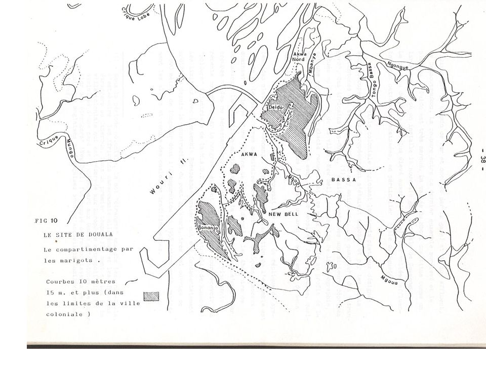
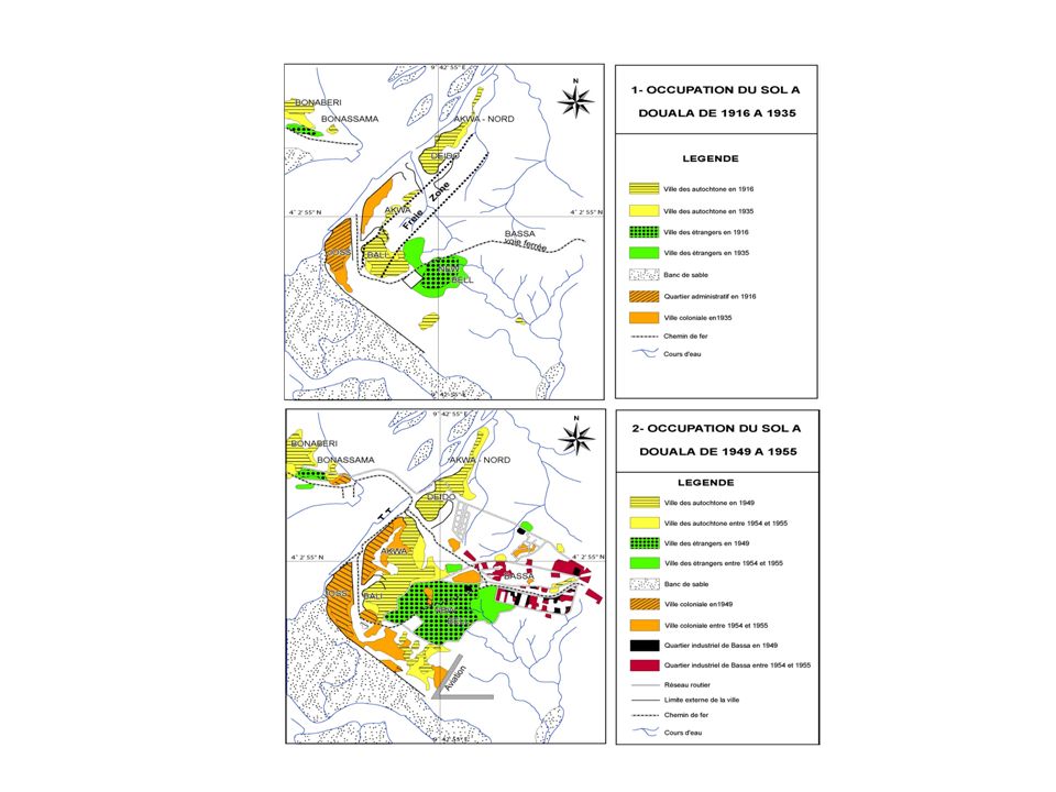
Evolution spatiale de Douala de 1964 à 1974

10
Fig. 8 – Etapes d'urbanisation et zones d'habitat spontané

11
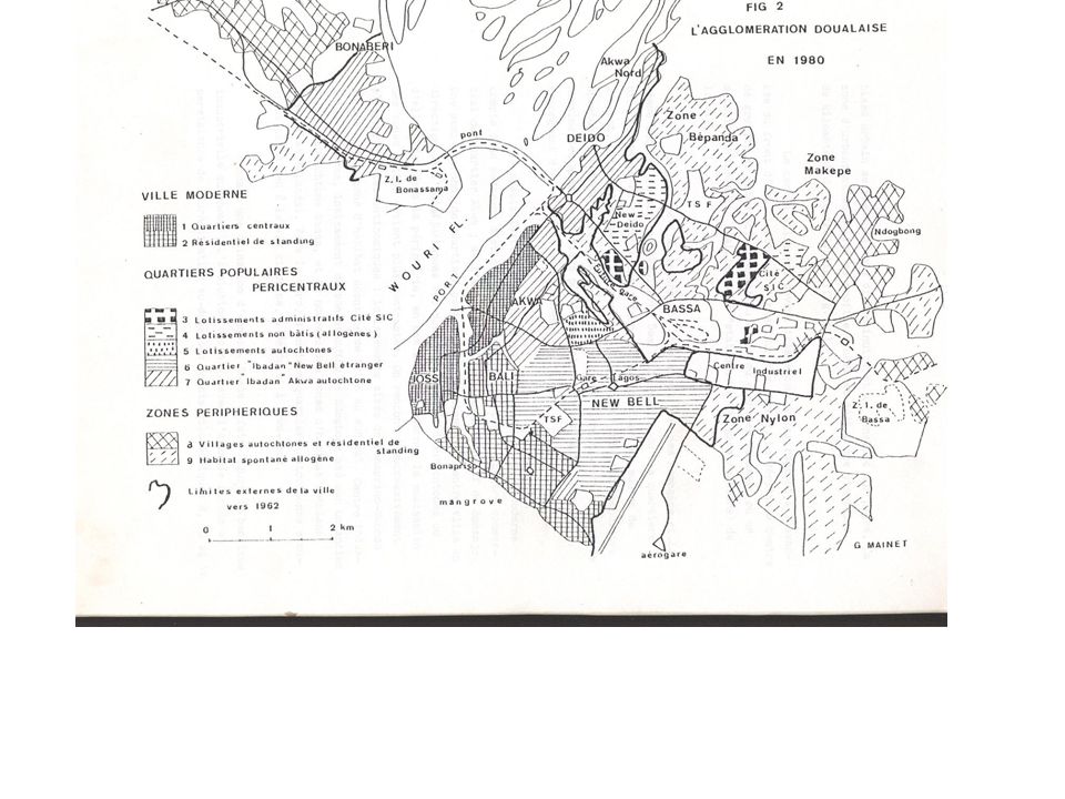
élargissement à l’horizon 2025

12
3- UMT or geographical units in Douala ( attributes and associated fonctions)
Port area ( 1000 ha) Industrial areas Administratif zone Planned residentials areas Unplanned, informal or sponteneous residential areas ( 35%) markets, Other Publics places (stadia…) Mangroves Forest ( relics or surrounding) Cultivated parcels ( to provide food and incomes…) Green spaces/parks ( put in place and preserve by the local governance autirity) Transports infrastructures: roads, rail ways, bridges ( 1 km) River Wouri, scanty water Sand ( plages) Poubelles sauvages ( tas d’ordures)
 Industrial areas. Administratif zone. Planned residentials areas. Unplanned, informal or sponteneous residential areas ( 35%) markets, Other Publics places (stadia…) Mangroves. Forest ( relics or surrounding) Cultivated parcels ( to provide food and incomes…) Green spaces/parks ( put in place and preserve by the local governance autirity) Transports infrastructures: roads, rail ways, bridges ( 1 km) River Wouri, scanty water. Sand ( plages) Poubelles sauvages ( tas d’ordures)")
13
1-Port area Attribute: 1000 ha; 500 exploited
1-Port area Attribute: ha; 500 exploited. Estuary Port; Fonction: 95% of importations of Cameroon and the central africa

14
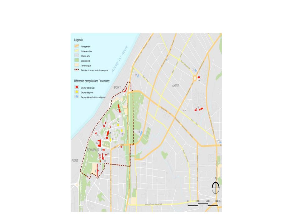
Port de Douala: situation Projet de développement)
")
15
Attributes: grouped in 2-3 zones Fonction: 70 % des industries
2- industrial areas: near the port in the old town and in Bonabéri ( rigth site of Wouri) Attributes: grouped in 2-3 zones Fonction: 70 % des industries
 Attributes: grouped in 2-3 zones. Fonction: 70 % des industries.")
16
Unit attributes fonction Habitat structuré Habitat spontannée Voies routières et ferroviaires Installations portuaires et industrielles Zone administrative Espace vert: Sauvage ( mangrove, jacinthe… Espace vert planté et entrtenu Zone d’agriculture intra urbaine. Zone commerciales (marcés)
")
18
Principaux points de blocage sur le réseau primaire et pôles économiques

19
MODELE NUMERIQUE DE TERRAIN

20
Land use map in Douala

22
Transects et delais

Présentations similaires


 Action Plan for Air Quality Improvement.>")


