Télécharger la présentation
La présentation est en train de télécharger. S'il vous plaît, attendez

1
Fouta Djallon Highlands Integrated Natural Resources Management Project (FDH-INRMP) Projet de Gestion Intégrée des Ressources Naturelles du Massif du Fouta Djallon (PGIRN-MFD) Dr. Afio ZANNOU Fouta Djallon Highlands Programme African Union Coordination Office, Conakry Dr. Frank BEERNEART CTP – FAO Presented at Freetown, October , 2010

2
Outline Plan Stakes and threats Enjeux et menaces
Necessity of a common approach Role of the AU Coordination office Institutional framework Project objectives Duration and partners Project Bodies Project components Key outputs Enjeux et menaces Necessité d’une approche commune Rôle du Bureau de Coordination de l’UA Cadre institutionnel Objectifs du Projet Durée et Partenaires Organes du Projet Composantes du Projet Résultats clés

3
--------------------------------------------------
STAKES OF PRESERVING THE FOUTA DJALLON HIGHLANDS (FDH) NATURAL RESOURCES The Fouta Djallon Highlands (FDH) home to some 8000 springs feeding into 15 rivers ENJEUX DE PRESERVATION DES RESSOURCES NATURELLES DU MASSIF DU FOUTA DJALLON Le Massif du Fouta Djallon abrite environ 8000 de ruisseaux qui alimentent dans 15 grands cours d’eau
 NATURAL RESOURCES. The Fouta Djallon Highlands (FDH) home to some 8000 springs feeding into 15 rivers ENJEUX DE PRESERVATION DES RESSOURCES NATURELLES DU MASSIF DU FOUTA DJALLON. Le Massif du Fouta Djallon abrite environ 8000 de ruisseaux qui alimentent dans 15 grands cours d’eau.")
4
7 major international rivers source from the FDH: Niger, Senegal, Gambia, Great scarcies, Little Scarcies, Koliba-Corubal, and Kayenga-Géba Trans-boundary watersheds of West Africa

5
Populations of Gambia, Guinea, Guinea Bissau, Mali, Mauritania, Niger,
Senegal, Sierra Leone, Benin, Nigeria

6
The core area with its extensions (reaching parts of Guinea- Bissau, Mali, Senegal and Sierra Leone) is km²
 is km²")
7
Supports a rich diversity of ecosystems: Forests, Savannah, mountains, river/ fresh water ecosystems within an altitude of 500 and 1500 m Une grande diversité d’écosystèmes: forêts, savannes, montagnes, eaux douces, entre une altitude variant entre 500 et 1500 m

8
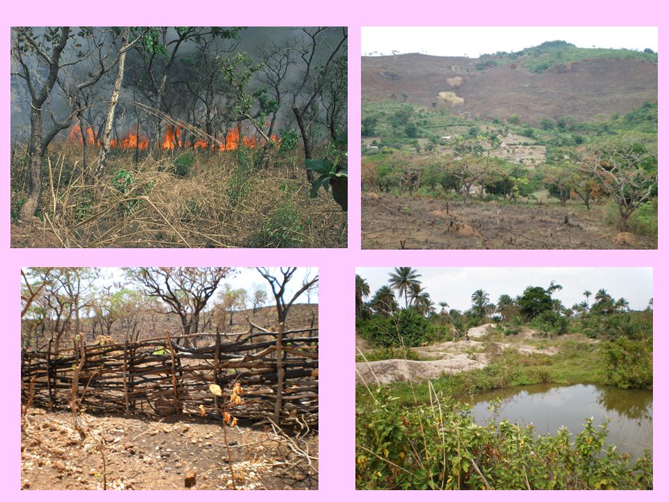
CURRENT THREATS AND PROBLEMS
Reduction of vegetation cover Acceleration of soil erosion Modification of soil characteristics and declines in fertility Reduction of flora, fauna, fish species Increased siltation and sedimentation of water courses Drying up of springs Gradual appearance of invasive aquatic weeds in the watercourses MENACES ET PROBLEMES ACTUELS Réduction de la couverture végétale Accélération de l’érosion des sols Modification des caractéristiques et déclin de la fertilité des sols Réduction des espèces de flore, faune, et de poisson Salinisation et sédimentation accrues des cours d’eau Assèchement des cours d’eau Apparition graduelle des végétaux aquatiques envahissants

9
CURRENT THREATS Garafiri/Konkouré Kinkon river, Pita

11
The 3rd Ministerial Conference of the Programme held in Bamako in July 1999 decided that:
The FDH-INRM project will build on the experiences of the Fouta Djallon Programme coordinated by ICO-AU which was aimed at promoting holistic approaches to integrated ecosystem management-based participatory and community-based strategies, as “the development of a common approach and vision in addressing the problems of the FDH”. to set-up the Regional Observatory on the Natural Resources of the FDH, to enable a consultation with actors and decision makers La 3e Conférence Ministérielle du Programme tenue en July 1999 à Bamako a décidé: Le projet est fondé sur les expériences du Programme du Fouta Djallon coordonné par l’ ICO-OAU en visant la promotion holistique de la gestion intégré des écosystèmes, basé sur des stratégies de participation des communautés, comme une approche et une vision commune pour faire face aux problèmes MFD. De mettre en place un Observatoire Régional du Massif Fouta Djallon pour suivre l’état des ressources et permettre une concertation dans les prises de décisions des acteurs et décideurs

12
Role of AU-Coordination Office
Coordination of Member States and other actors for the preservation of the FDH natural resources Harmonization of policies within Member Sates for natural resources management Advocacy for the promotion of the strategic international character of the Fouta Djallon Highlands Facilitation for resource mobilization Monitoring of FDH natural resources Rôle du Bureau de Coordination de l’UA Coordination des actions avec les Etats membres et autres acteurs pour la préservation des ressources naturelles du MFD Harmonisation des politiques au sein des Etats membres pour la gestion des ressources naturelles ces Plaidoyer pour le caractère stratégiques du MFD Mobilisation des ressources Suivi des ressources naturelles

13
Historical background of the FDH-INRM Project
Developed between 2000 and 2005 by Member Countries, AU-ICO, FAO and UNEP Submitted to GEF Council and approved for funding in November 2005 Final GEF approval October 2008 The Project has been launched on 01 July 2009 Historique du Projet de GIRN-MFD

14
INSTITUTIONAL ANCHORAGE
AFRICAN UNION (AU) DEPARTMENT OF RURAL ECONOMY AND AGRICULTURE OF THE AFRICAN UNION COMMISSION MINISTERIAL CONFERENCE (MC) AFRICAN UNION INTERNATIONAL COORDINATION OFFICE (AU-ICO) NATIONAL FOCAL POINTS OF THE FDH PROGRAMME REGIONAL CONSULTATIVE COMMITTEE (RCC) REGIONAL OBSERVATORY OF FOUTA DJALLON HIGHLANDS SPECIFIC PROJECTS CONTRIBUTING TO FDH PROGRAMME FDH-INRM Project/GEF
 DEPARTMENT OF RURAL ECONOMY AND AGRICULTURE OF THE AFRICAN UNION COMMISSION. MINISTERIAL CONFERENCE. (MC) AFRICAN UNION INTERNATIONAL COORDINATION OFFICE. (AU-ICO) NATIONAL FOCAL POINTS OF THE FDH PROGRAMME. REGIONAL CONSULTATIVE COMMITTEE. (RCC) REGIONAL OBSERVATORY OF FOUTA DJALLON HIGHLANDS. SPECIFIC PROJECTS CONTRIBUTING TO FDH PROGRAMME. FDH-INRM. Project/GEF.")
15
Objectives of the FDH-INRM Project
Development objective: To ensure the conservation and sustainable management of the natural resources of the Fouta Djallon Highlands over the medium- to long-term (2025) in order to improve rural livelihoods of the populations directly or indirectly dependent on the FDH. Objectif de développement: Assurer la conservation et la gestion durable des ressources naturelles du Massif Fouta Djallon sur le moyen et long terme (2025) en vue d’améliorer le niveau de vie des populations directement ou indirectement dépendantes du MFD.
 in order to improve rural livelihoods of the populations directly or indirectly dependent on the FDH Objectif de développement: Assurer la conservation et la gestion durable des ressources naturelles du Massif Fouta Djallon sur le moyen et long terme (2025) en vue d’améliorer le niveau de vie des populations directement ou indirectement dépendantes du MFD.")
16
Environmental objective: To mitigate the causes and negative impacts of land degradation on the structural and functional integrity of the ecosystem of the Fouta Djallon Highlands through the establishment of a regional legal and institutional framework and strengthened institutional capacity designed to facilitate regional collaboration in the management of the FDH, assessment of the status of natural resources in the FDH and development of replicable, community-based sustainable land management models. Objectif environnemental: Atténuer les causes et impacts négatifs de la dégradation des terres sur l’intégrité fonctionnelle des écosystèmes du Massif du Fouta Djallon à travers l’établissement d’un cadre légal et institutionnel régional et d’une capacité institutionnelle renforcée destinés à faciliter la collaboration régionale dans la gestion du MFD, l’évaluation de l’état des ressources naturelles du MFD et le développement des modèles communautaires de gestion des terres transposables.

17
Duration and Partners of the FDH-INRM Project
Duration: 10 years: Tranche I (4 years) + Tranche II (6 years) Requesting Countries: Gambia, Guinea, Guinea-Bissau, Mali, Mauritania, Niger, Senegal, Sierra Leone Regional Implementing Agency: African Union - International Coordination Office (AU-ICO) Executing Agency: FAO Implementing Agency: UNEP Other partners: ECOWAS, RBO, CILSS, ICRAF-CIFOR, GM, …. Durée et Partenaires du PGIRN-MFD Durée: 10 ans : Tranche I (4 ans) + Tranche II (6 ans) Pays demandant: Gambie, Guinée, Guinée-Bissau, Mali, Mauritanie, Niger, Sénégal, Sierra Leone Agence Régionale de mise en oeuvre: Bureau de Coordination International de l’Union Africaine (BCI-UA) Agence d’Exécution : FAO Agence de mise en oeuvre: PNUE Autres partenaires: CEDEAO, OB, CILSS, ICRAF-CIFOR, GM, …
 + Tranche II (6 years) Requesting Countries: Gambia, Guinea, Guinea-Bissau, Mali, Mauritania, Niger, Senegal, Sierra Leone. Regional Implementing Agency: African Union - International Coordination Office (AU-ICO) Executing Agency: FAO. Implementing Agency: UNEP. Other partners: ECOWAS, RBO, CILSS, ICRAF-CIFOR, GM, … Durée et Partenaires du PGIRN-MFD. Durée: 10 ans : Tranche I (4 ans) + Tranche II (6 ans) Pays demandant: Gambie, Guinée, Guinée-Bissau, Mali, Mauritanie, Niger, Sénégal, Sierra Leone. Agence Régionale de mise en oeuvre: Bureau de Coordination International de l’Union Africaine (BCI-UA) Agence d’Exécution : FAO. Agence de mise en oeuvre: PNUE. Autres partenaires: CEDEAO, OB, CILSS, ICRAF-CIFOR, GM, …")
18
The FDH-INRM Project Bodies / Les Organes du PGIRN-MFD
UNEP GEF IMPLEMENTING AGENCY REGIONAL OBSERVATORY OF THE FOUTA DJALLON HIGHLANDS PROJECT STEERING COMMITTEE (PCS) INTERNATIONAL BUREAU OF COORDINATION OF AFRICAN UNION (IBC-AU) FAO PROJECT EXECUTING AGENCY REGIONAL PROJECT COORDINATION UNIT (RPCU) SCIENTIFIC AND TECHNICAL COMMITTEE (STC) NATIONAL FOCAL POINTS (NFP) GAMBIA NTPU GUINEA NTPU GUINEA- BISSAU NTPU MALI NTPU MAURITANIA NTPU NIGER NTPU SENEGAL NTPU SIERRA LEONE NTPU LPSU Kamakwe LPSU LPSU Mamou Labé LPSU Gabu LPSU Kéniéba LPSU Kédougou
 INTERNATIONAL BUREAU OF COORDINATION. OF AFRICAN UNION. (IBC-AU) FAO. PROJECT EXECUTING AGENCY. REGIONAL PROJECT COORDINATION UNIT. (RPCU) SCIENTIFIC AND TECHNICAL COMMITTEE. (STC) NATIONAL FOCAL POINTS (NFP) GAMBIA. NTPU. GUINEA. NTPU. GUINEA- BISSAU. NTPU. MALI. NTPU. MAURITANIA. NTPU. NIGER. NTPU. SENEGAL. NTPU. SIERRA LEONE. NTPU. LPSU. Kamakwe. LPSU LPSU. Mamou Labé. LPSU. Gabu. LPSU. Kéniéba. LPSU. Kédougou.")
19
Project Financing Arrangement
GEF: Project: US$ 11,000,000 Co-financing (In-kind & Cash Total): US$ 33,000,000 Governments: US$ 15,000,000 African Union: US$ 3,150,000 FAO: US$ 1,142,000 Beneficiaries: US$ 3,000,000 Donors: US$ 10,708,000 Total Project Cost: US$ 44,000,000 FINANCEMENT FEM: 11,000,000 USD Co-financement (en Nature et Espèces): 33,000,000 US$ Gouvernements: 15,000,000 US$ Union Africaine: 3,150,000 US$ FAO: 1,142,000 US$ Bénéficiaires: 3,000,000 US$ Donateurs: 10,708,000 US$ Coût Total du Projet : US$ 44,000,000
: US$ 33,000,000. Governments: US$ 15,000,000. African Union: US$ 3,150,000. FAO: US$ 1,142,000. Beneficiaries: US$ 3,000,000. Donors: US$ 10,708,000. Total Project Cost: US$ 44,000, FINANCEMENT. FEM: 11,000,000 USD. Co-financement (en Nature et Espèces): 33,000,000 US$ Gouvernements: 15,000,000 US$ Union Africaine: 3,150,000 US$ FAO: 1,142,000 US$ Bénéficiaires: 3,000,000 US$ Donateurs: 10,708,000 US$ Coût Total du Projet : US$ 44,000,000.")
20
Component 1: Enhanced regional collaboration in the planning and implementation of NRM activities Composante 1: Renforcement de la collaboration régionale dans planification et la mise en œuvre des activités de gestion des ressources naturelles

21
Subcomponent 1.1. International status and framework conventions
Establishment of a legal and institutional framework, strengthen cooperation between the states in the management of transboundary natural resources of the FDH. Sous-composante 1.1. Statut international et conventions-cadres Etablir un cadre juridique et institutionnel complet et consensuel en vue de consolider la coopération entre les pays participants en matière de gestion des ressources naturelles partagées et transfrontières du MFD.

22
Subcomponent 1.2. National laws, regulations and institutions
Laws need to be adapted, harmonized, disseminated and implemented, based on the declaration on the international character of the FDH and the framework convention for regional cooperation. Sous-composante 1.2. Lois, réglementations et institutions nationales Les lois et réglementations relatives à l’utilisation des ressources naturelles doivent être adaptées, harmonisées, diffusées et exécutées en application de la reconnaissance du caractère international du MFD et de la convention-cadre de coopération régionale.

23
Subcomponent 1.3. Regional Observatory of the Fouta Djallon
Creation at IBC-AU of an “Observatory” to assess, evaluate, and monitor changes of the status of natural resources in the FDH. Inventory and monitoring of the status of natural resources in selected pilot sites and transboundary areas. Assessment of the status of the resources (land cover, soils, waters, animal, plant species, biodiversity, etc.) Land and ecosystem degradation trends Thematic maps (landscape units, vegetation and forest types, soils and vulnerable areas, protected areas, etc.). Sous-composante 1.3. Observatoire régional du Fouta Djallon Création d’un “observatoire” au BCI-UA pour l’évaluation et le suivi des changements intervenant dans l’état des ressources naturelles du MFD. Inventaire et suivi technique de l’état des ressources naturelles dans les sites pilotes et les zones transfrontières sélectionnés. Evaluation détaillée de l’état des ressources (occupation des terres, sols, eaux, espèces végétales et animales, biodiversité, etc.) Dégradation des écosystèmes Cartes thématiques (unités de paysage, types de végétation et de forêts, sols et zones fragiles, zones protégées, etc.).
 Land and ecosystem degradation trends. Thematic maps (landscape units, vegetation and forest types, soils and vulnerable areas, protected areas, etc.). Sous-composante 1.3. Observatoire régional du Fouta Djallon. Création d’un observatoire au BCI-UA pour l’évaluation et le suivi des changements intervenant dans l’état des ressources naturelles du MFD. Inventaire et suivi technique de l’état des ressources naturelles dans les sites pilotes et les zones transfrontières sélectionnés. Evaluation détaillée de l’état des ressources (occupation des terres, sols, eaux, espèces végétales et animales, biodiversité, etc.) Dégradation des écosystèmes. Cartes thématiques (unités de paysage, types de végétation et de forêts, sols et zones fragiles, zones protégées, etc.).")
24
Component 2: Improved natural resources management and livelihoods in the FDH Composante 2: Amélioration de la gestion des ressources naturelles et des conditions de vie dans le massif du Fouta Djallon

25
Subcomponent 2.1. Integrated natural resources management in the pilot sites and watersheds
Interventions in 29 pilot sites and 6 transboundary watersheds Community-based natural resources management plans. In each of the 6 headwaters, at least 1 of the 29 pilot sites will be located. 14 former pilot sites already exist (all in Guinea), 15 new sites defined (4 in Guinea, 5 in Mali, 2 in Senegal, 2 in Guinea-Bissau and 2 in Sierra Leone). Additional funding will be mobilized to establish pilot sites in Gambia, Mauritania and the Niger. Sous-composante 2.1. Gestion intégrée des ressources naturelles dans les sites pilotes et les bassins versants Interventions dans 29 sites pilotes et 6 bassins hydrographiques transfrontières. Plans de gestion communautaire des ressources naturelles. Au moins un des 29 sites pilotes sera situé dans chacune des six régions amont. 14 sites pilotes existent déjà été en Guinée de projets antérieurs 15 sites nouveaux (4 en Guinée, 5 au Mali, 2 au Sénégal, 2 en Guinée-Bissau et 2 en Sierra Leone). Des fonds supplémentaires seront engagés pour établir des sites pilotes en Gambie, en Mauritanie et au Niger.
, 15 new sites defined (4 in Guinea, 5 in Mali, 2 in Senegal, 2 in Guinea-Bissau and 2 in Sierra Leone). Additional funding will be mobilized to establish pilot sites in Gambia, Mauritania and the Niger. Sous-composante 2.1. Gestion intégrée des ressources naturelles dans les sites pilotes et les bassins versants. Interventions dans 29 sites pilotes et 6 bassins hydrographiques transfrontières. Plans de gestion communautaire des ressources naturelles. Au moins un des 29 sites pilotes sera situé dans chacune des six régions amont. 14 sites pilotes existent déjà été en Guinée de projets antérieurs. 15 sites nouveaux (4 en Guinée, 5 au Mali, 2 au Sénégal, 2 en Guinée-Bissau et 2 en Sierra Leone). Des fonds supplémentaires seront engagés pour établir des sites pilotes en Gambie, en Mauritanie et au Niger.")
26
Subcomponent 2.2. Alternative income generation
In conformity with subcomponent 2.1, improve peoples’ capacity to interact with markets and identify new income-generating opportunities to improve the livelihoods. Sous-composante 2.2. Nouvelles sources de revenus conforme aux sous-volet 2.1, renforcer les capacités de la population à avoir accès aux marchés et d’identifier de nouvelles activités génératrices de revenu en vue d’améliorer leurs conditions de vie.

27
Component 3: Increased Stakeholder Capacity in Integrated NRM Composante 3: Renforcement des capacités des parties prenantes en gestion intégrée des ressources naturelles

28
Subcomponent 3.1 Mobilization and Training of Stakeholders in INRM
Train and strengthen local community institutions, community-based organizations and other stakeholders in natural resources management and institutional development. Special provision for stakeholders from Gambia, the Niger and Mauritania to participate also in various capacity-building activities. Linked to institutional mechanisms in subcomponent 1.2 Sous-composante 3.1 Mobilisation et formation des parties concernées en gestion intégrée des ressources naturelles Former et consolider les institutions communautaires locales, les organisations de base communautaire et autres parties concernées par la gestion des ressources naturelles et le développement institutionnel. Dispositions particulières pour permettre aux parties prenantes de la Gambie, du Niger et de la Mauritanie de participer aussi aux différentes activités de renforcement des capacités. Relié à l’établissement des mécanismes institutionnels dans le sous-volet 1.2

29
Component 4: Project Management, M&E, and Information Dissemination Compossante 4: Gestion du projet, suivi et évaluation, diffusion de l’information

30
Subcomponent 4.1. Project management structures
Ensure the needed institutional and administrative structures are put in place for effective implementation of the Project in a timely and cost-effective manner. Sous-volet 4.1. Structures de gestion du projet Veiller à ce que toutes les structures institutionnelles et administratives requises pour l’exécution du projet soient mises en place en temps voulu et de manière rationnelle:

31
Subcomponent 4.2. Monitoring and evaluation system
Monitoring and evaluation at three levels: Project outcomes and impacts in relation to the logical framework; Delivery of project outputs in accordance with the annual work plans; Monitoring of project implementation and performance. Develop a monitoring and evaluation system, providing accurate and timely information on project implementation A cost effective M&E system conform to UNEP and FAO procedures evolving GEF guidance, linked to the Observatory, progressively responsible for monitoring project impact Sous-volet 4.2. Système de suivi et d’évaluation Suivi et l’évaluation sur trois niveaux: Résultats et les incidences du projet par rapport à la matrice de planification; Livraison des résultats conformément aux plans de travail annuels Suivi de l’exécution et des réalisations du projet. Mise en place un système de suivi et d’évaluation permettant de fournir des données précises et en temps voulu sur les réalisations du projet. Système de suivi et d’évaluation économique, conforme aux procédures du PNUE et de la FAO, et évoluera en fonction des directives du FEM, étroitement lié à l’observatoire qui sera progressivement chargé d’assurer le suivi d’impact du projet.

32
Subcomponent 4.3. Information Dissemination
Disseminate information to address key institutional, cooperation, technical and socio-economic barriers that could impinge on the project achieving its objectives. Sous-volet 4.3. Diffusion de l’information Diffusion des informations sur les difficultés liées barrières des institutions, de coopération, de nature technique et au contexte socio-économique pouvant entraver le bon déroulement du projet.

33
Key steps & outputs / Etapes & résultats clés
CTP FAO recruited and Project launched on 01 July 2009 First technical meeting with Focal Points in Kindia (Guinea), Sept 2009 First meeting of Project Steering Committee in Bamako, November 2009 Nomination of the Head of the Regional Observatory, November 2009 Recruitment of Monitoring & Evaluation Specialist, 2010 The AU Coordinator assumes the coordination of Regional coordination Unit Recrutement du CTP FAO en Mai 2009 et démarrage du Projet, 01 July 2009 Première réunion technique avec les Points Focaux, Kindia, Guinée, Sept 2009 Première réunion du Comité de Pilotage à Bamako, Novembre 2009 Nomination du Responsable de l’Observatoire Régional, Novembre 2009 Recrutement du Suivi-Evaluateur, 2010 Le Coordonnateur de l’UA assume la coordination de l’Unité Régionale de Coordination
, Sept First meeting of Project Steering Committee in Bamako, November Nomination of the Head of the Regional Observatory, November Recruitment of Monitoring & Evaluation Specialist, The AU Coordinator assumes the coordination of Regional coordination Unit Recrutement du CTP FAO en Mai 2009 et démarrage du Projet, 01 July Première réunion technique avec les Points Focaux, Kindia, Guinée, Sept Première réunion du Comité de Pilotage à Bamako, Novembre Nomination du Responsable de l’Observatoire Régional, Novembre Recrutement du Suivi-Evaluateur, Le Coordonnateur de l’UA assume la coordination de l’Unité Régionale de Coordination.")
34
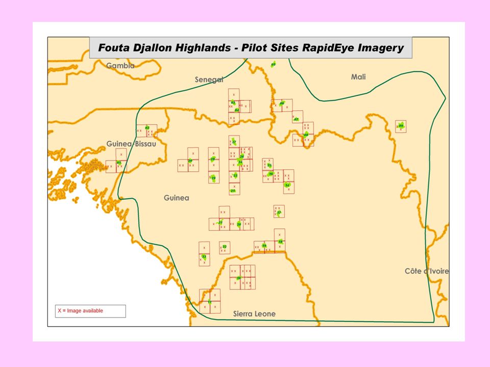
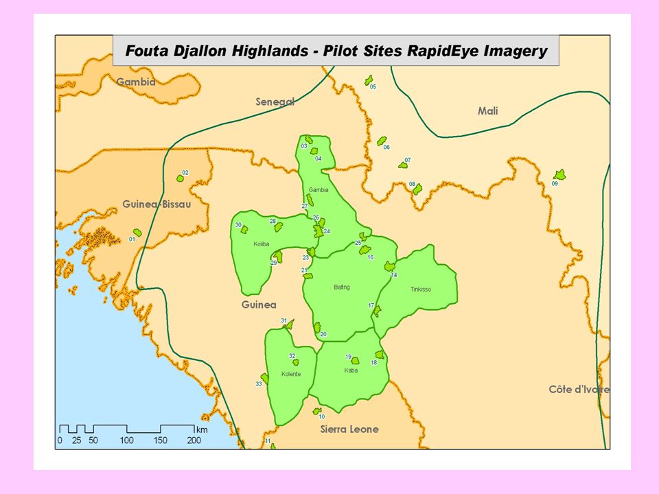
Selection of the 29 pilot sites of FDH-INRMP Sélection des 29 sites pilotes du PGIRN-MFD
Countries Sites River Basin Main tributaries Com/RDC Sub-Prefecture Lat long Guinea 1. Bassa - Kimbissi Samou Kimbissi Friguiagbé 9°55’ 13°00’ 2. Garafiri barrage /Léfouré Konkouré Konkoureno Garafiri / Linsan 10°30’ 12°30’ 3. Gaoual Koliba Komba/Tominé Gaoual. 11°45’ 13°15’ 4. Labatara Mongo Walawalako Soloya-Maréla 10°15’ 11°15’ 5. Guetoya/Bantiguel Kokoulo Bantiguel 11°7’ 12°15’ 6. Banga Koliba/corubal Komba Balaya 12°45’ 7. Tolo - Bafing Source Sénégal Guilinti Tolo 8. Baleng Kaba Kagnako/ oumouwomol Ouré-Kaba 10°10’ 11°40’ 9. Dissa -Souguéta Kolente Konka Sougueta – Farinta 10. Koundou Linsan 11. Horé-Dimma Gambie Cours principal Tountouroun 11°30’ 12. Mini Niger Tinkisso Kalinko 11°00’ 13. Fangan-Balabori Senegal Bafing Kenieoula 14. Nyalen Watala 10°45’ 15. Silamé Doubel 16. Songhe-Donde Silamé Daraméré 17. Souloundé 12°00’ 18. Diaforé Diaforé Mali 1. Faranda Falémé Faraba 2. Bilali-Ko /Linguekoto Kéniéba 3. Dialafara Dialafara 13°30’ 4. Fari-Sagalo Sagalo 12°10’ 5. Kôba - Naréna Naréna 8°35’ 1. Kabatekinda Gambia Tomboroncoto 2. Tenkoto Bandafassi 12°40 12°5’ Guinea Bissau 1. Gam Besse Corubal/Koliba Rio Nhadjhaba 14°45’ 2. Dara - Jaima Kayenga-Géba 14°00’ Sierra Leone 1. Makoboya Kaba-Little Scarcies Kamakwei 9°30’ 2. Kabamon-Kawula Kolenté-Great Scarcies Kambia 9°10’ 12°55’

37
Key outputs / Résultats clés
Setting-up of the Observatory Two preliminary expert meetings: Bamako, Dec 2006 & Niamey, 8-10 July 2008 Three Documents: 1. Observatory Action Plan, 2. Observatory Monitoring indicators/parameters, 3. Data collection networks The documents will be adopted by the Ministerial Conference Mise en place de l’Observatoire Deux réunions préparatoires d’experts: Bamako, Déc and Niamey, 8-10 Juillet 2008 Trois Documents: 1. Action Plan de l’Observatoire, 2. Indicateurs de suivi des ressources naturelles de l’Observatoire 3. Réseau de collecte des données Ces documents seront adoptés par la Conférence Ministérielle

38
Key outputs / Résultats clés
Setting-up of the Observatory Digitalization of five thematic maps (April 2010) Website built (May 2010): Observatory offices are built in AU Conakry (October 2010) State of the NRM and environmental indicators implemented by the Observatories in West Africa (August, 2010) Selection of 8 normalized monitoring sites (On-going consultation) Mise en place de l’Observatoire Digitalisation de 5 cartes thématiques (Avril 2010) Site Web construit ( Mai 2010): Bureaux de l’Observatoire construits (UA Conakry, Octobre 2010) Etat des lieux de mise en œuvre de GRN et de l’environnemental par les Observatoires en Afrique de l’Ouest (Août, 2010) Sélection des 8 sites normalisés de l’Observatoire (en cours)
 Website built (May 2010): Observatory offices are built in AU Conakry (October 2010) State of the NRM and environmental indicators implemented by the Observatories in West Africa (August, 2010) Selection of 8 normalized monitoring sites (On-going consultation) Mise en place de l’Observatoire. Digitalisation de 5 cartes thématiques (Avril 2010) Site Web construit ( Mai 2010): Bureaux de l’Observatoire construits (UA Conakry, Octobre 2010) Etat des lieux de mise en œuvre de GRN et de l’environnemental par les Observatoires en Afrique de l’Ouest (Août, 2010) Sélection des 8 sites normalisés de l’Observatoire (en cours)")
39
Key outputs / Résultats clés
Atlas of the Observatory of the Fouta Djallon Highlands (April 2010) The Atlas is intended for decision-makers and other actors in the West African Region worried about the sustainable management of natural resources in the highlands and other extension areas Atlas de l’Observatoire Régional du Massif du Fouta Djallon (Avril 2010) L’Atlas de l’Observatoire Régional du Massif du Fouta Djallon est un produit à l’attention des décideurs et autres acteurs de la région Ouest-Africaine préoccupés par la gestion durable des ressources naturelles de ce Massif et de ses extensions
 The Atlas is intended for decision-makers and other actors in the West African Region worried about the sustainable management of natural resources in the highlands and other extension areas Atlas de l’Observatoire Régional du Massif du Fouta Djallon (Avril 2010) L’Atlas de l’Observatoire Régional du Massif du Fouta Djallon est un produit à l’attention des décideurs et autres acteurs de la région Ouest-Africaine préoccupés par la gestion durable des ressources naturelles de ce Massif et de ses extensions.")
40
Key outputs / Résultats clés
Draft Framework Cooperation between AU/FDH Programme, River Basin Organizations (MRU, NBA, OMVG, OMVS), and ECOWAS (March 2010) Protocole d’Accord cadre de Coopération entre le Programme Massif du Fouta Djallon de l’Union Africaine et les Organismes de Bassin (MRU, ABN, OMVG, OMVS) et la CEDEAO (Mars 2010)
, and ECOWAS (March 2010) Protocole d’Accord cadre de Coopération entre le Programme Massif du Fouta Djallon de l’Union Africaine et les Organismes de Bassin (MRU, ABN, OMVG, OMVS) et la CEDEAO (Mars 2010)")
41
Key outputs / Résultats clés
ToRs of the baseline studies for the 29 pilot sites Recruitment of the national and international consultants for the baseline studies (on-going) TdR des études de références sur les 29 sites pilotes Recrutement du consultant international et des consultants nationaux (en cours)
 TdR des études de références sur les 29 sites pilotes. Recrutement du consultant international et des consultants nationaux (en cours)")
42
THANKS MERCI

Présentations similaires