Télécharger la présentation
La présentation est en train de télécharger. S'il vous plaît, attendez

1
RainGain o INTERREG NWE: http://www.nweurope.eu/http://www.nweurope.eu/ o HQ in Lille, National Contact Point there too, o financial instrument of the European Union's Cohesion Policy o funds projects which support transnational cooperation o tackle shared problems of Member States, regions and other authorities o prime role of communication o keep records of meetings etc. o 50% cofinancing max. o no national coordinator, but a national site.

2
RainGain WP1 A1 Radar acquisition A2 Radar installation and testing WP1 A3 Appraisal of existing rainfall data Output: Radars NL, F Output: report on testing Output: presentations at pilots (Nat Obs Groups) A4 Future use and ownership of radar Output: agreement with future owner (NL)
 A4 Future use and ownership of radar Output: agreement with future owner (NL)")
3
Safety norms Two norms that are rather for energy of non-ionazing radiations in the range 10MHz-10GHz: –UTE C 18-610, 1995: <10W/m 2 –ICNIRP, 1998: <0,08 W/kg ( UTE/2) –Public values -> x 5 for « professionals »
 –Public values -> x 5 for « professionals »")
4
Safety norms NO access during radar functioning Radiation focused in the beam Should not intercept building or people (except for very limited time) Negligible residual radiation ( -30 dB) Only for qualified staff Recommended not to intercept office or lodgin Interest of high location to avoid hign shooting angle 2.5 m (exclusion area) 60 m ( «professional» area) 1 km ( «public» area)
 Negligible residual radiation ( -30 dB) Only for qualified staff Recommended not to intercept office or lodgin Interest of high location to avoid hign shooting angle 2.5 m (exclusion area) 60 m ( «professional» area) 1 km ( «public» area)")
5
Interest of having two radars (X of RainGain, C of Météo-France at Trappes) rather far apart Storms generally from West, discharges from East, East of Paris: - low visibility from Trappes –Important test field for urban research (Marne-la-Vallée), –in particular within the programme « Numerical City » –PST Paris-Est on urban systems –Several gauge networks (>2 x 30) + C-band radar Location
 rather far apart Storms generally from West, discharges from East, East of Paris: - low visibility from Trappes –Important test field for urban research (Marne-la-Vallée), –in particular within the programme « Numerical City » –PST Paris-Est on urban systems –Several gauge networks (>2 x 30) + C-band radar Location")
6
Orographic masks and ground clutter (R= 60 km) Orographic mask (%) and groun clutter (dBZ) for elevations 0.5° et 1.5 ° ° Few orographic mask (<10%) aux élévations 0.5° gournd clutter at short distance (<10km) jusquà 1.5 ° (Novimet, 2010)
 Orographic mask (%) and groun clutter (dBZ) for elevations 0.5° et 1.5 ° ° Few orographic mask (<10%) aux élévations 0.5° gournd clutter at short distance (<10km) jusquà 1.5 ° (Novimet, 2010)")
7
Implementation

8
OVer Descartes+ (24,37 + 10 m) Over ENPC (19 + 10 m)
 Over ENPC ( m)")
9
Areas of 60 m and 1 km (ENPC)
")
10
Area of 1 km ENPC without pylon (113, 5 m.) and angle= 1°, 1,5°. Main problems: Max (Green Valley) 32 m. vs. 24,37 m. = Max(Descartes+) vs. 19 m = Max (ENPC, with technical shelter) Examples of solutions: ENPC + pylon 10m et angle de 1.07 °, Descartes + pylon 10 m et angle 0,17 ° (for buildings at 950 m.).
 32 m. vs. 24,37 m. = Max(Descartes+) vs. 19 m = Max (ENPC, with technical shelter) Examples of solutions: ENPC + pylon 10m et angle de 1.07 °, Descartes + pylon 10 m et angle 0,17 ° (for buildings at 950 m.)..")
11
Visite des sites pour implantation radar ENPC Tour TDF CHENNEVIERES SUR MARNE Château eau TORCYBâtiment NOISY-LE-GRAND Bâtiments Habitations VILLEJUIF et LE KREMLIN BICETRE Tour RODIN CHAMPIGNY SUR MARNE Château deau NOISIEL Bâtiment Habitations FONTENAY SOUS BOIS

12
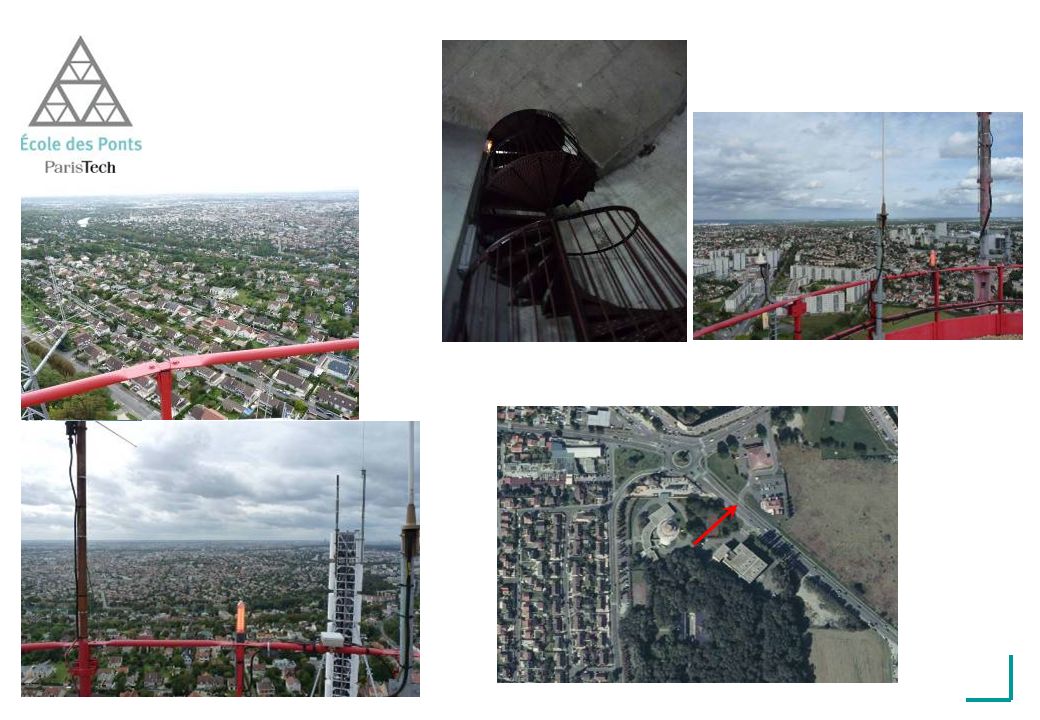
Visite des sites pour implantation radar Château eau des TOTEMS Localisation : Noisiel Propriétaire : Veolia eau Hauteur : environ 60 m (Z = 161 m) Diamètre : 22 m Distance de lENPC : 2,5 km Occupant : SFR, ORANGE, BOUYGUES, RADIO MLV, VALLEE FM, RATP Accès : Escalier en colimaçon sur 60 m puis échelle droite jusquau sommet Directive pour accès : Demande dautorisation et Procédure dintervention à envoyer avant chaque visite Demande pour implantation : Convention avec opérateur présent (ANFR), Accord Commission site et servitude
 Diamètre : 22 m Distance de lENPC : 2,5 km Occupant : SFR, ORANGE, BOUYGUES, RADIO MLV, VALLEE FM, RATP Accès : Escalier en colimaçon sur 60 m puis échelle droite jusquau sommet Directive pour accès : Demande dautorisation et Procédure dintervention à envoyer avant chaque visite Demande pour implantation : Convention avec opérateur présent (ANFR), Accord Commission site et servitude")
14
Visite des sites pour implantation radar Tour TDF Localisation : Chennevière sur Marne Propriétaire : TDF Hauteur : 122.70 m (Z = 225 m ) Diamètre : 10 m sur la partie sommitale Distance de lENPC : 8,4 km Occupant : SFR, ORANGE, BOUYGUES, Free, Relais TNT, radios diverses Accès : Ascenseur sur 104 m puis escaliers en colimaçon finissant sur courte échelle droite Directive pour accès : Autorisation permanente sur le site si visite toujours réalisée par le demandeur dimplantation du radar et non pas par un prestataire Demande pour implantation : TDF se charge de tout (attente proposition commerciale)
 Diamètre : 10 m sur la partie sommitale Distance de lENPC : 8,4 km Occupant : SFR, ORANGE, BOUYGUES, Free, Relais TNT, radios diverses Accès : Ascenseur sur 104 m puis escaliers en colimaçon finissant sur courte échelle droite Directive pour accès : Autorisation permanente sur le site si visite toujours réalisée par le demandeur dimplantation du radar et non pas par un prestataire Demande pour implantation : TDF se charge de tout (attente proposition commerciale)")
16
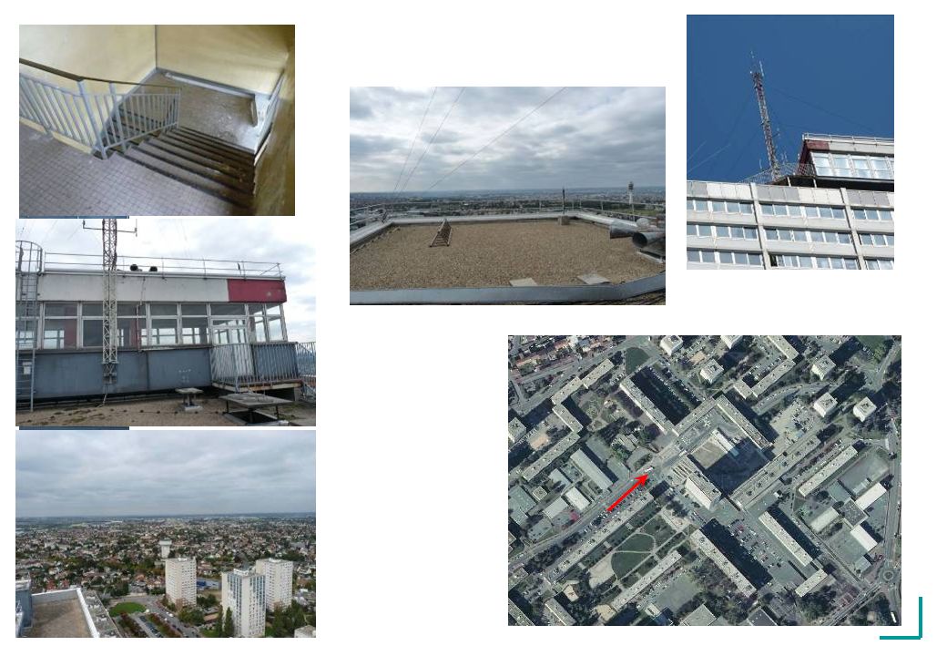
Visite des sites pour implantation radar Tour Rodin : Localisation : Champigny sur Marne Propriétaire : Paris Habitat Hauteur : 90 m (Z = 190 m ) Partie sommitale : rectangulaire 10x7m Distance de lENPC : 8,4 km Occupant : aucun Accès : Ascenseur sur 80 m puis escaliers normaux avec paliers. Puis deux courtes échelles droites. Directive pour accès : Autorisation permanente sur le site en passant par le PC sécurité de la tour dhabitation. Demande pour implantation : Avis dun bureau de contrôle (contact proposé) et autorisation préfecture Val de Marne (car Immeuble Grande Hauteur)
 et autorisation préfecture Val de Marne (car Immeuble Grande Hauteur).")
18
Autres sites pour implantation radar Bâtiment Habitations VILLEJUIF Hauteur : 45 m (Z = 160 m ) Distance de lENPC : 21,8 km Bâtiment Habitations KREMLIN BICETRE Hauteur : 31 m (Z = 143 m ) Distance de lENPC : 21,4 km
 Distance de lENPC : 21,8 km Bâtiment Habitations KREMLIN BICETRE Hauteur : 31 m (Z = 143 m ) Distance de lENPC : 21,4 km")
19
Autres sites pour implantation radar Bâtiment Habitations FONTENAY SOUS BOIS Hauteur : 80 m (Z = 181 m ) Distance de lENPC : 13,6 km Bâtiment NOISY LE GRAND Hauteur : 50 m (Z = 147 m ) Distance de lENPC : 4,7 km
 Distance de lENPC : 13,6 km Bâtiment NOISY LE GRAND Hauteur : 50 m (Z = 147 m ) Distance de lENPC : 4,7 km")
20
Autres sites pour implantation radar Château eau de TORCY Hauteur : 41 m (Z = 133 m ) Distance de lENPC : 6,9 km
 Distance de lENPC : 6,9 km")
Présentations similaires


 Analysis of instruments and actions to support eco-innovation and eco-investment.>")


 - D1 - 01/03/2000 FTR&D/VERIMAG TAXYS : a tool for the Development and Verification of RT Systems a joint project between France Telecom.>")


